
Written by Marco Reyes, maritime history researcher with over a decade studying Age of Discovery navigation routes and their lasting impact on global trade.
You’ve heard about explorers who changed history. But imagine being a sailor in 1520 — no GPS, no satellite maps, no guarantee the route even exists — and your captain sends you into a freezing, fog-choked maze of islands at the bottom of the world, hoping to find a path to the Pacific.
That’s exactly what happened with Magellan’s Pass — one of the most consequential navigational discoveries in human history. If you’ve been trying to understand what it is, where it is, why it mattered, and why people still talk about it today, this article answers all of it.
What Is Magellan’s Pass?
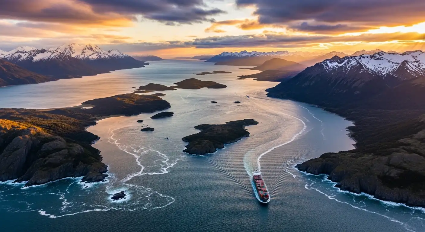
Magellan’s Pass — more formally known as the Strait of Magellan — is a natural waterway at the southern tip of South America. It separates mainland South America to the north from the Tierra del Fuego archipelago to the south, and is considered the most important natural passage between the Atlantic and Pacific oceans.
The strait is approximately 570 km long and just 2 km wide at its narrowest point. That’s barely wider than some rivers — yet ships carrying entire cargoes of trade goods had to squeeze through it.
The name “Magellan’s Pass” is often used informally, but the official name honors the same man: Ferdinand Magellan, the Portuguese explorer who first navigated it in 1520.
What makes this pass unique isn’t just its geography. It’s the fact that it was the only reliable westward route from Europe to Asia for nearly 400 years — until the Panama Canal changed everything.
Magellan’s Pass Explained with a Real Scenario
Picture yourself as a Spanish merchant captain in 1600. You need to move a cargo of silver from the Atlantic coast to trading partners in Asia.
Your options are grim. Going east around Africa adds thousands of miles. Attempting to sail around Cape Horn — the very southern tip of South America — means battling what sailors called “the furious fifties,” a region of near-constant gale-force winds and icebergs. Many ships were lost there.
Magellan’s Pass offered a middle option: difficult, but survivable. The strait is sheltered on both sides by land, which blocks the worst of the open-ocean winds. Yes, the route is narrow and the weather is cold and foggy. But compared to Cape Horn, it was the lesser of two evils.
Before the opening of the Panama Canal in 1914, the Strait of Magellan was an important route for steamships moving between the Atlantic and Pacific Oceans. Despite the difficulty of navigating through the strait, vessels preferred the route since it was shorter and safer than the infamous Drake Passage.
That trade-off — difficulty versus danger — is exactly why Magellan’s Pass defined global commerce for centuries.
How Magellan’s Pass Was Discovered: A Step-by-Step Account
The discovery didn’t happen by accident. It was the result of a deliberate, grueling search.
- September 1519 — The fleet departs Spain. The Magellan–Elcano expedition departed with the purpose of securing a maritime trade route to the Spice Islands in present-day Indonesia.
- Late 1519 — Coastline search begins. The five-ship fleet sailed south along the eastern coast of South America, looking for a passage through the continent.
- March 1520 — Forced to overwinter. By the third week of March, weather conditions had become so desperate that Magellan decided they should find a safe harbour to wait out the winter before resuming the search.
- October 21, 1520 — The breakthrough. On 21 October 1520, they spotted a headland at 52°S latitude which they named Cape Vírgenes. Past the cape, they found a large bay. While exploring the bay, a storm erupted — and the ships reported that the storm had drawn them through a narrow passage not visible from sea.
- 38 days of navigation. It took Magellan 38 days to complete the crossing — threading through narrow channels, fighting unpredictable winds, and losing one ship to desertion along the way.
- November 28, 1520 — Pacific reached. Magellan reached the Pacific Ocean on November 28, naming it for its seemingly still waters.
This six-step process — from departure to breakthrough — reshaped how every navigator after him thought about the world.
Sruffer DB: The Complete Guide for 2026
Common Mistakes and Misconceptions About Magellan’s Pass
Several things get misunderstood about Magellan’s Pass. Here are the most common ones:
Mistake 1: Magellan sailed around the world. He didn’t complete the circumnavigation himself. He was killed in the Philippines in 1521, before the journey ended. It was his navigator, Juan Sebastián Elcano, who brought the last ship home to Spain.
Mistake 2: The pass is easy to navigate today. Modern ships still find it challenging. The narrowness of the natural passage and unpredictable weather make maritime piloting compulsory for all vessels passing through. You can’t simply sail through without a licensed pilot on board.
Mistake 3: The Panama Canal replaced it entirely. Not true. Supertankers and very large bulk carriers that can’t fit through the canal’s locks still use Magellan’s Pass regularly. Size limitations on the Panama Canal keep the strait commercially relevant to this day.
Mistake 4: Magellan was Spanish. He was Portuguese. He sailed under the Spanish flag after disagreements with the Portuguese Crown, but his nationality was Portuguese.
Magellan’s Pass vs. Drake Passage: Key Comparison
These two routes are often confused or treated as interchangeable. They’re not.
| Feature | Magellan’s Pass | Drake Passage |
|---|---|---|
| Type | Sheltered inland strait | Open ocean route |
| Length | ~570 km | ~800 km |
| Width | 2–35 km | ~800 km wide |
| Weather | Cold, foggy, unpredictable winds | Extremely violent, gale-force winds |
| Risk | Navigational complexity | Icebergs, storms, massive waves |
| Best for | Motor vessels, steamships | Large sailing ships needing maneuverability |
| Pilot required? | Yes, mandatory | No |
| Still used today? | Yes | Yes (mostly yachts and research vessels) |
The key insight most people miss: sailing ships historically preferred Drake Passage over Magellan’s Pass, because the open water gave them room to maneuver. The strait’s curving channel with unpredictable winds and tidal currents left sailing ships with very little room to work. Steamships, on the other hand, preferred Magellan’s Pass because they didn’t need wind and could handle the narrow passages with engine power.
Pro Tips for Understanding Magellan’s Pass
Whether you’re a history student, a geography enthusiast, or someone preparing to visit Patagonia, here’s what most articles won’t tell you:
- Punta Arenas is your anchor point. It became the primary refueling port for steamships in transit and remains the key city for anyone exploring the region today. It sits on the Brunswick Peninsula and is the southernmost significant city in Chile.
- The lighthouse network is extraordinary. There are 41 lighthouses standing along the 570 km strait, some of which are declared national monuments. Before GPS, these were the only guides sailors had through the fog and narrow channels.
- Wildlife makes this route unique. The region surrounding the strait is home to penguins, whales, and dolphins, making it a popular destination for ecotourism alongside its historical significance.
- The strait lies almost entirely in Chile. It sits entirely within Chilean territorial waters, except for its easternmost extremity touching Argentina — making it one of Chile’s most strategically important geographic assets.
- The strategic angle nobody talks about: controlling Magellan’s Pass historically meant controlling trade between two oceans. This is why Chile’s claim to the strait carries geopolitical weight even today, long after the Panama Canal reduced its commercial importance.
Frequently Asked Questions About Magellan’s Pass
Q1: Where exactly is Magellan’s Pass located?
It sits at the southern tip of South America, separating the Chilean mainland from Tierra del Fuego. The eastern entrance lies between Cape Vírgenes and Cape Espíritu Santo, and the western exit opens into the Pacific near Cape Pillar.
Q2: How long does it take to sail through Magellan’s Pass today?
Modern vessels typically take 1–2 days to transit the strait, depending on weather and ship speed. Magellan himself took 38 days because he was charting completely unknown territory with no maps.
Q3: Is Magellan’s Pass still used for shipping?
Yes. Large vessels that can’t fit through the Panama Canal — such as supertankers and oversized bulk carriers — still regularly use the Strait of Magellan. It handles significant commercial traffic annually.
Q4: Why is it called Magellan’s Pass if he didn’t discover it alone?
The King of Spain, Emperor Charles V, who sponsored the expedition, renamed it the Strait of Magellan in Ferdinand’s honor. Magellan died before returning home, but the Spanish crown ensured his name lived on through the passage he found.
Q5: What is the original name Magellan gave the strait?
Magellan originally named it Estrecho de Todos los Santos — meaning “Strait of All Saints” — after the religious feast day on which he first entered it.
Q6: How does Magellan’s Pass compare to the Panama Canal?
The Panama Canal is artificial, roughly 82 km long, and faster for most ships. But it has strict size restrictions — vessels above certain dimensions simply cannot use it. Those ships still rely on natural passages like the Strait of Magellan.
The Lasting Legacy of Magellan’s Pass
Magellan’s Pass isn’t just a historical footnote. It’s proof that one determined navigator, pushing into an unknown maze of ice-cold channels, can permanently alter the course of global commerce and exploration.
The Magellan expedition achieved the first circumnavigation of Earth in history, proved that ships could sail around the world on a western sea route, and revealed the vast scale of the Pacific Ocean to European understanding.
The strait that bears Magellan’s name remains navigable, relevant, and awe-inspiring today. If you want to go deeper, start with a map of the southern tip of South America and trace the route yourself — from Cape Vírgenes in the east to Cape Pillar in the west. Every bend in that channel has a story behind it.
